Adventure Guide FAQ
Below are the most frequently asked questions about Adventure Guide, and how to make the most of this brilliant route planning resource.
What is Adventure Guide and who is it for?
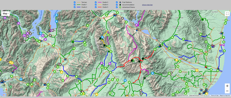
The heart of Adventure Guide is the Adventure Map, which contains detailed information on over 1,000 of the South Island’s BEST adventure routes, plus over 1,500 points of interest including campsites, huts, fuel stations, and epic vehicle assessable locations (called AdventureTokens).
All the routes and locations on the map are personally visited, photographed and documented to ensure the information is the highest quality available.
This is the LARGEST resource of its kind, making it the perfect tool for adventure riders, four-wheel drivers, or any roving explorer looking to discover epic routes and remote locations!
Does Adventure Guide have an app?
Yes, Adventure Guide has a dedicated navigation app. It comes preloaded with the largest collection of routes, campsites, huts, fuel stations and AdventureTokens which bypasses the conventional (and time-consuming) task of manually loading GPX files to your GPS or phone. The app makes life so easy!
You can get the app here: Adventure Guide Navigator
Should I use the app, or the website?
The app and website are quite different in the way they work, each with their own strengths.
Adventure Guide Navigator (app): this is a dedicated navigation app designed for vehicle navigation. It is a true offline satellite navigation app allowing you to explore the most remote places in the South Island, even where there is no internet coverage. Each route and point of interest on the app has comprehensive information that you can view, no matter where you are. This makes the app perfect for following a pre-planned route, or spontaneously planning the next day’s route while sitting around a crackling campfire in the middle of nowhere.
Adventure Guide website: this is best used for the purpose of planning your trips on a large screen device. The website has thousands of photos that can’t fit on the app, which means the website offers a very visual way to select routes and locations that you want to explore. You can view the website on a phone, however it is a far better experience on a large screen device like a PC, laptop or tablet.
How do I use the Adventure Guide Navigator app?
Everything you need to know about installing and using the app can be found here: Adventure Guide Navigator
Can I download GPX files?
Yes! You can download GPX files to use on your GPS, or your preferred phone navigation app. It is worth noting that the Adventure Guide Navigator avoids the need to download individual GPX files as it comes preloaded with EVERYTHING on the Adventure Map. Plus, the Navigator has an “Update” button that will update the app with all the latest additions, and updates with the single tap of a button –a huge timesaver.
How do I use the website?
There are two main maps for planning your trips.
Option #1 - Adventure Map:
As a free user, you will see 30 sample routes on the Adventure Map. As a supporter, you will see over 1,000 of the best South Island routes on the Adventure Map, alongside the campsites, huts, fuel stations, and AdventureTokens.
The Adventure Map shines when used for discovering places to explore. With so many great routes and locations on the map, you’ll be like a kid in a candy store!
Clicking on each route or point of interest, will open up the corresponding information page. This information page includes all the details, photos, updates, plus a downloadable GPX file.
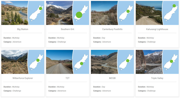
Option #2 - Adventures
Adventures are like tour itinerary packages, put together from first-hand experiences over a period of 15+ years. There are single day Adventures, and multi-day Adventures, with all of them containing everything you need to know to hit the trails!
Adventures are ideal if you don’t have the time to do any research, or you simply want a turn-key style itinerary made up of the best routes. All the hard work of route planning is done for you!
Adventures come with a printable PDF booklet, allowing you to take a glovebox or tank bag version of the Adventure with you. The booklet provides all the route details and information on attractions, fuel stops, food supplies, dining options, camping options, hotel accommodation, seasonal access information and route cautions. And of course, Adventures come with downloadable GPX files for navigation on a GPS or phone of your choice.
What GPS devices work with Adventure Guide?
If you prefer using a dedicated GPS device for navigation, the GPX files you’ll get from Adventure Guide work on all GPS devices capable of loading off-road type GPX files.
The Garmin range of outdoor GPS units are great options, and are recommended. Garmin GPS units including the 700 series, Zumo series, or 276Cx offer larger screen sizes, and provide a nice user experience when navigating. You can get motorbike or 4X4 mounts for all these GPS devices, so the GPS can be conveniently and securely mounted when you are navigating.
If you want a GPS that you can use for navigation, plus outdoor activities such as tramping, hunting etc, then the Garmin 65 series and 66 series are great handheld GPS options. Do note that while handheld GPS devices have the convenience of being able to be used for both recreation activities and navigation, some users do not like the smaller screen size of the handhelds for in/on-vehicle navigation.
What phone apps work with Adventure Guide?
Both Android and iOS phones require a map navigation app to open and view GPX files, and overlay them on a map. Without this type of app, your phone won’t know how to handle GPX files.
If you are considering using your phone for navigation and you don’t have a map navigation app, then it is worth trying the Adventure Guide Navigator app. It is designed specifically for exploring the South Island, and comes preloaded with the largest collection of routes and points of interest.
If you already have phone navigation app installed, you can download the GPX files from Adventure Guide, and load them to your navigation app.
How do I stitch tracks together to make a single GPX file?
You do not need to stitch GPX routes together to use Adventure Guide GPX files. However, if you choose to, you can stitch a selection of individual tracks together to make your own custom GPX file for an entire day, or a multi-day trip. Having just one GPX file for the trip can make life a little easier when you are out on the trails as it avoids having to switch from one individual GPX file to the next, throughout the day.
There are many route editing software options out there. Some are free, and some have a fee. Basecamp by Garmin is a good option. This is free to use and has lots of great features.
Do you have South Island and North Island Routes?
Josh Martin is the man behind logging all the routes on Adventure Guide. He lives in the South Island, and has dedicated over 15 years of his life to travelling over 350,000 km personally riding, logging, photographing and documenting every track on the Adventure Map.
Josh is continually out on the trails, and exploring new ones, to keep Adventure Guide the most up-to-date track resource. While there are a couple of North Island Adventures available, Adventure Guide has gained the reputation of being the South Island route resource bible.
How do I know the grade of each route?
All the routes on the Adventure Map are graded (with colour coding) to make trip planning a breeze. Grade 1 is at the easier end offering an experience that is more scenic, than challenging. Grade 5 is at the difficult end, providing great options for those that like a good challenge! There is an excellent map key on the Adventure Map explaining the differences between grades 1, 2, 3, 4 and 5.
I’m new to adventuring – is Adventure Guide for me?
Absolutely! While the Adventure Map does contain a lot of “hardcore” tracks to satisfy the seasoned adventurers who are eager for a challenge, most of the tracks on the Adventure Map are mid-grade tracks. These mid-grade tracks are grade 1, 2 and 3 and are more remote and scenic, rather than challenging or hard on your vehicle. These tracks can be successfully ridden/driven by unmodified motorbikes and 4X4 vehicles offering epic and memorable adventures.
Additionally, the Adventure Map includes a high number of gravel backroads that are excellent to help you link together your adventure route. You may be surprised at just how many gravel backroads pass through some truly amazing places, and are absolutely worth including on your next trip.
I’m an experienced adventurer looking for challenging tracks – is Adventure Guide for me?
Absolutely! The Adventure Map contains a lot of excellent grade 4 and grade 5 tracks to satisfy adventurers keen on a challenge!
What if I need help with using Adventure Guide?
Questions are normal, and we welcome you to ask away. All subscribers to Adventure Guide have an open line of communication for help and support. Got a question? Flick us an email at [email protected] and we’ll be happy to help.